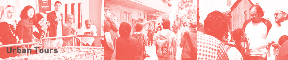
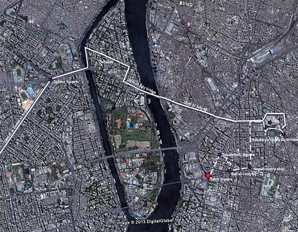
See map for Downtown tour led by Mohamed Elshahed
Downtown
This tour examined locations, typologies, urban conditions, challenges and opportunities that can be found in the urban core or the city center. The urban core includes areas of vastly diverse patterns and conditions, which together form the city center. It contrasts with Cairo’s two other major urban categories, the informal belt and the desert city. The urban core is comprised of the historic city, its nineteenth century expansion, and subsequent development that took place between 1950 and 1970. It has changed in piecemeal fashion because of Egypt’s social, economic and political conditions, all of which are constantly in flux.
The tour began on foot with an exploration of parts of the “Downtown” area (nineteenth and twentieth century) and continued to Azbakiyya, the area that links pre- and post-nineteenth century expansion. From Azbakiyya, we boarded a bus for a brief tour of the districts of Zamalek and Mohandiseen, located on the West bank of the Nile. The tour returned east via University Bridge and culminated at the pre-nineteenth century historic core for a final exploratory walk. Themes covered in this tour included governance, public space, transport and infrastructure.

Mohamed Elshahed
Mohamed Elshahed is a doctoral candidate in the Middle East and Islamic Studies Department at New York University. He lives in Cairo, where he is conducting dissertation research on architecture and urban planning in Egypt from 1939 to 1965, with an emphasis on the Nasser era. His dissertation examines popular discourse on the architectural transformation from anticolonial nationalism to postcolonial developmentalism in Egypt. Elshahed has a Bachelor of Architecture from the New Jersey Institute of Technology and a Master in Architecture Studies from Massachusetts Institute of Technology. He currently blogs at Cairobserver.
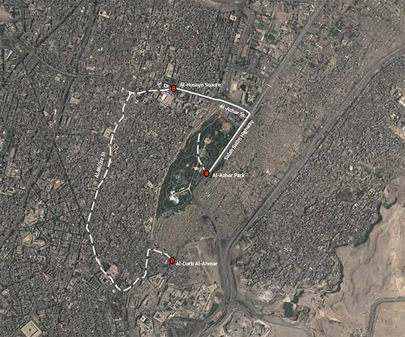
See map for Islamic Cairo tour led by May Al-Ibrashy
Islamic Cairo
The capital of Egypt shifted from Alexandria in the North to its current location at the southern tip of the Delta with the Islamic conquest in 624. Over the next three centuries, the core of the capital shifted northward from al-Fustat in the South to walled al-Qahira (walled Cairo). Cairo continued to expand in all directions while retaining its Islamic core as a vibrant living settlement. This tour concentrated on the urban history of this core and its shifting relationship with the modern city. It also looked at issues of conservation and situated them in wider questions of administration, governance, conflicting rights to heritage and public space, and the politics and economics of urban development and upgrading.
We started our tour at the original outskirts of the city, walking through one of the cemeteries into al-Darb al-Ahmar, one of Islamic Cairo’s main thoroughfares and recently the subject of multiple conservation efforts. We continued through the square and the street introduced in the nineteenth and early twentieth century in the original, tightly-knit fabric of the city, passing through al-Qasaba (literally ‘the spine,’ currently called al-Mu’izz Street), al-Qahira’s main street. The tour followed another modern street, al-Azhar, into al-Husayn Square, where our bus transported us through Salah Salem Highway to al-Azhar Park. Here, it was possible to catch a glimpse of al-Qahira’s Eastern Cemetery, al-Sahra’. Our final destination, al-Azhar Park, featured an impressive view of the eastern section of Islamic Cairo, and in particular al-Darb al-Ahmar.

May Al-Ibrashy
May Al-Ibrashy is an architect with twenty-one years of field experience in implementation of conservation projects in Islamic Cairo. She was previously a founding partner in Hampikian-Ibrashy, a Cairo-based conservation architecture firm with a five-year portfolio in conservation, documentation, consultation, training and research. Al-Ibrashy holds post-graduate and doctoral degrees in architectural history, archaeology and urban history from the University of London. Currently she is founder and chair of the Built Environment Collective, an Egyptian NGO working on issues of the built environment operating through its architectural hub and workspace Megawra. She is also Adjunct Lecturer of Architecture at the American University in Cairo and Ain Shams University.
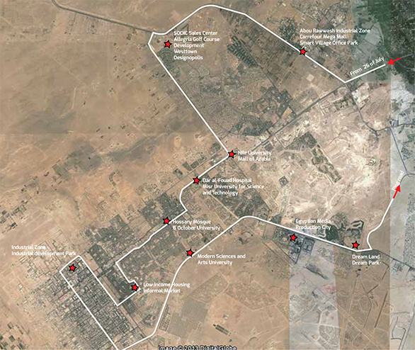
See tour map for 6th of October led by Nabeel Elhady and Richard N. Tutwiler
Sixth of October and the New Cities program
In 1969, President Gamal Abdel Nasser launched the Greater Cairo Region Master Scheme, which would later produce the New Towns Policy in 1977 under President Anwar Sadat. As originally conceived, Egypt would build four new satellite cities in the desert within a 40km (25 mi) radius of Cairo and a further four new towns beyond. The new settlements would serve several purposes: draw population away from overcrowded Cairo; alleviate pressure on the Egyptian environment, economy, and physical infrastructure; and better distribute the population over the territory of the country. Each new town would be largely self-sufficient, with its own administrative structure, institutions, and economic activities, but linked to the capital with “development corridors.” The new towns were centrally planned, and each design contained provisions for a central commercial and administrative area, subdivisions for individual housing, low-income housing estates, and upscale, gated communities.
Following law no. 59 of 1979, a New Urban Communities Authority (NUCA) within the Ministry of New Settlements implemented a series of measures to encourage rapid new town development that included cheap land prices, tax holidays, provision of utilities, and easy permitting arrangements. The bulk of public money for urban development was earmarked for the New Towns Program, and amid great fanfare and considerable public interest, the new cities began to emerge from the dry desert land.
Founded in 1981, 6th of October City to the west of Cairo is the largest new town at about 400 km2 (154 mi2) in area with an initial planned population of around 500,000. In comparison with other new towns outside Cairo, it is perhaps the most rapidly developed and provides the visitor with an excellent example of broader development trends among the current list of eight new towns around Cairo.
Despite being fairly close (35 km or 21 mi) to central Cairo via the 26th of July corridor, construction and, especially population growth, have been disappointingly slow when compared to the original plan. After 32 years, there are probably fewer than 250,000 permanent residents. Most of the constructed houses and apartments are either unfinished or not inhabited. Although the industrial zone developed quickly, and hundreds of businesses are now located there, most of the jobs associated with these industries are filled by workers who commute from Cairo on a daily basis. Sixth of October has its share of new universities and upmarket international schools, but again, most of the students are commuting from Cairo rather than living in the new town itself. Construction and economic growth has been uneven and discontinuous. Rather than an organic growth starting with the city center core and moving outwards in ever-expanding circuits and growth lines, the city is a patchwork of developed and undeveloped parcels of land. Observers have noted that the pattern of uneven growth reflects the often-haphazard way land was allocated to developers, as well as the often-speculative nature of real estate development in the new towns. As David Sims has observed, “All new towns around Cairo are characterized by empty lots, stalled construction, huge empty concessions, and skeletal subdivisions.” Beyond implementation issues, why have new towns failed to grow as rapidly as planned? Numerous reasons have been cited. The first is that roads and buildings are not enough to draw people from Cairo. Basic urban utilities and services have failed to keep pace with building construction, as patchy as that may be. There is a remarkable lack of affordable public transport in a city whose distances and dimensions appear to be designed for private car owners. The low-income housing estates are not attracting the people they were meant to serve because of poor location and communication. Most low-income workers prefer to stay where they are, a commute to work away in 6th of October, rather than relocate their families. Ironically, the high-income housing is also not attracting as many new residents as it might. Luxurious standards and restrictions on use of real estate, not to mention considerable associated expenses with living in gated communities or subdivisions of individual homes, make living in upscale housing expensive. Although housing, either low- or high-income, does get bought, much of the ownership is for speculative purposes, rather than immediate residency. Although 6th of October has attracted some white-collar employers such as private universities and hospitals, employment opportunities for middle class professionals are still overwhelmingly in Cairo. Most often, even those middle-class home owners who left crowded Cairo for spacious villas in 6th of October, perhaps ironically, pass factory workers each morning commuting into 6th of October while they themselves are commuting out of the new town to their office jobs back in Cairo.
Sources: Bush, R., and H. Ayeb 2012. Marginality and Exclusion in Egypt. AUC Press. Sims, D. 2010. Understanding Cairo. AUC Press. Stewart, D. 1996. Cities in the Desert: the Egyptian New Town Program. Annals of the Association of American Geographers, 86:3 pp.459-480. Wahdan, D. 2013. Planning Egypt’s New Settlements: the Politics of Spatial Inequities. AUC Press.

Part 2

Nabeel Elhady
Nabeel Elhady is an architect and professor at Cairo University. He initiated and organized for five years the annual architectural students’ competition. Besides his academic responsibilities he is a practicing architect through his private practice Noon since 1998. Through the projects undertaken by his office, continuous attempts are made to blend theories with realities to bring about architecture that respects humanity and nature.
Richard N. Tutwiler
Richard N. Tutwiler is a research director specializing in rural development and natural resource management in the Middle East and North Africa. He has been Research Professor and Director of AUC’s Desert Development Center since 2001. Author of numerous publications on sustainable development, Tutwiler was a co-winner of the Consultative Group for International Agricultural Research Chairman’s Award for Outstanding Scientific Article in 2000. His current research activities include desert development in Egypt and water management in the Nile Basin. Tutwiler earned his B.A. in Cultural Anthropology from Macalester College and his M.A. and Ph.D. degrees from the State University of New York at Binghamton, where he also earned graduate diplomas in Middle East Studies. Tutwiler received The President’s Distinguished Service Award of the American University in Cairo in 2008.
See map for Boulaq El-Dakrour tour led by Khaled Abdel Halim
Boulaq El Dakrour
Giza has grown informally on agricultural land. Informal areas in the Governorate of Giza are classified into two main categories:
1. Unsafe areas: 25 informal areas are classified as unsafe, second priority, including shacks and deteriorated old village cores.
2. Unplanned areas: consolidating and consolidated informal areas, which form the majority of urban Giza, including Boulaq El Dakrour, Ard El Lewa, Imbaba, Waraq, Moneeb and others.
Boulaq El Dakrour is one of the largest informal areas in Giza, with 1.2 million inhabitants and an area of nine km2 (3.5mi2) . The Participatory Development Programme in Urban Areas of the German Development Cooperation (GIZ) worked in Giza from 2002 to 2007 with various methods: applying a participatory upgrading approach; implementing a variety of projects and improvements that employ these participatory tools; and getting local administration to cooperate with local NGOs and communities. The projects include: improving infrastructure through a €5 million grant from KfW, a major German development bank, (for sewage, water and covering parts of a canal) and community projects to refurbish youth centers, microbus stops, markets, and other initiatives.
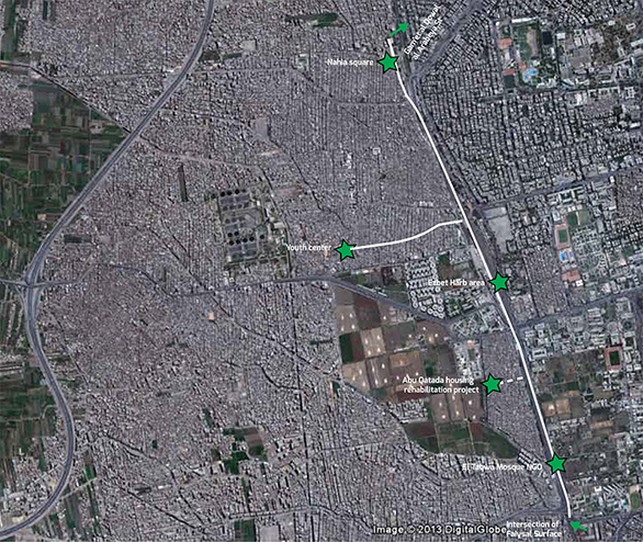
This tour started at the intersection of Faiysal Surface (under the bridge) and El Zomor Canal Road, and ended at Gamet El Dowal El Arabia Street near the Nahia Bridge.
Sources
Khalil, Omnia. Egyptian Urban Action. http://egyptianurbanaction.blogspot.com/ The Participatory Development Program in Urban Areas, Egypt (PDP) www.egypt-urban.de

Khaled Abdelhalim
Khaled Abdel Halim graduated as an architect/planner from Cairo University in 1990, received an M.A. in Architecture and Housing Studies from the University of Newcastle, UK in 1995, and Ph.D. in Housing Policy, Planning and Practice from the University of Central England in Birmingham, UK in 2003. He worked for more than six years for the German International Cooperation (GIZ-Egypt) in participatory upgrading of informal areas and has also acted as consultant and report ontributor to UNHabitat on strategic district and governorate planning in Egypt. Dr. Abdel Halim is a lecturer at the Department of Architecture at Helwan University and currently Visiting Assistant Professor of Urban Policy at the Amercian University in Cairo. Dr. Abdel Halim has been executive director of the Local Development Observatory at the Local Administration Reform Unit, a UNDP program which measures good governance and local development. He is a founding member of the Egyptian Earth Construction Association and TAKAMOL Foundation for Integrated Development.
See map for Ezbit El-Haggana tour led by Yahia Shawkat
Ezbit El-Haggana
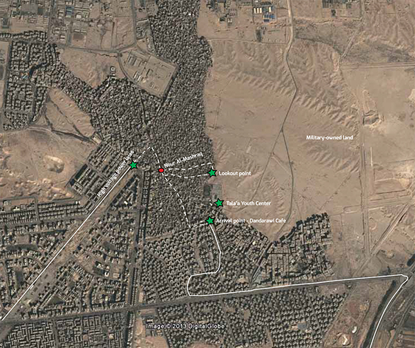
Ezbit El-Haggana is a self-built community that settled in the early 1960s on desert land at the 4.5km (2.8mi) mark on the Cairo-Suez highway. At the time, this was a deserted fringe of Cairo, where military training grounds were located. Today, Ezbit El-Haggana is home to anywhere from tens of thousands, to a million people – depending on who you ask – and is divided into five areas, each with its own character. The first area is the original settlement, stretching northward from the Cairo-Suez highway to the overhead power lines to the South. It is the best served, and social ties are strong given its homogenous origin. The military originally granted this land to a particular corps of troops, the Haggana, a camel riding border patrol, for members and their families to live on. As the families grew larger, the settlement expanded with the army’s support, and land was sold to the Haggana’s descendants for a symbolic 10 piasters per square meter. By the late 1960s, once construction on the Nasr City district was underway, a three-way land dispute over land ownership erupted between public sector developer Madinet Nasr for Housing and Development, the Cairo Governorate, and the military. It is no surprise that the military prevailed; the Nasr City master plan would have to end abruptly where the Haggana’s military-owned land begun.
The second, third and fourth areas were built in the 1970s and 1980s and catered to families, predominantly from Upper Egypt, that migrated to Cairo in search of work. By then, the military bases had been transformed into a hub of industry, with military-owned factories that attracted jobs and labor. These three areas embody a more extreme deprivation than the original settlement, since they are located in the heart of Ezbit El-Haggana, further away from the main streets that surround it. Especially precarious is the third area, where shacks are built on the cheapest available land in the area, which happens to be underneath high-voltage power lines. The fifth area is the most recent addition to Ezbit El-Haggana and can easily be identified by the mid-rise, concrete apartment blocks that have capitalized on its proximity to a main road to the south of Ezbit El-Haggana. This area embodies the neoliberal era’s real estate boom, where most of the buildings were built by one rich speculator, who happens to be a former member of parliament.
Sources

Yahia Shawkat
Yahia Shawkat is a built environment researcher and critiques built environment policy on his blog, Shadow Ministry of Housing. The Right to Housing Initiative, which identifies a greater right to housing that encompasses other rights like land, water and energy and aims to map social justice in the built environment on a national level, involves the production of a series of short documentaries in addition to a guide for civil society, activists and students. Shawkat is also a housing and land rights researcher with the Egyptian Initiative for Personal Rights and has taught part-time at AUC. In 2008, he curated the Egyptian Pavilion at the 11th Venice Architecture Biennale. Shawkat holds a B.Sc. in Architecture from Cairo University.